Posted on

10/09/2020 — DIRECTED ENERGY WEAPON (DEW) caught BEAMING at Tyndall Air Force base, Florida – Space Wing – creating HOT Spot in a field at the base

October 9, 2020 350am Central time

This video, and post documents a directed energy beam which has been caught on WEATHER SATELLITE beaming down directly at Tyndall Air Force Base (space force communications base) along the coast of Florida, creating a hot spot at the location receiving the beam as well.

See the full event as I captured it live early this morning, as well as the hot spot detected at the base where the beam was pointing…

(below: right click to view image larger size)

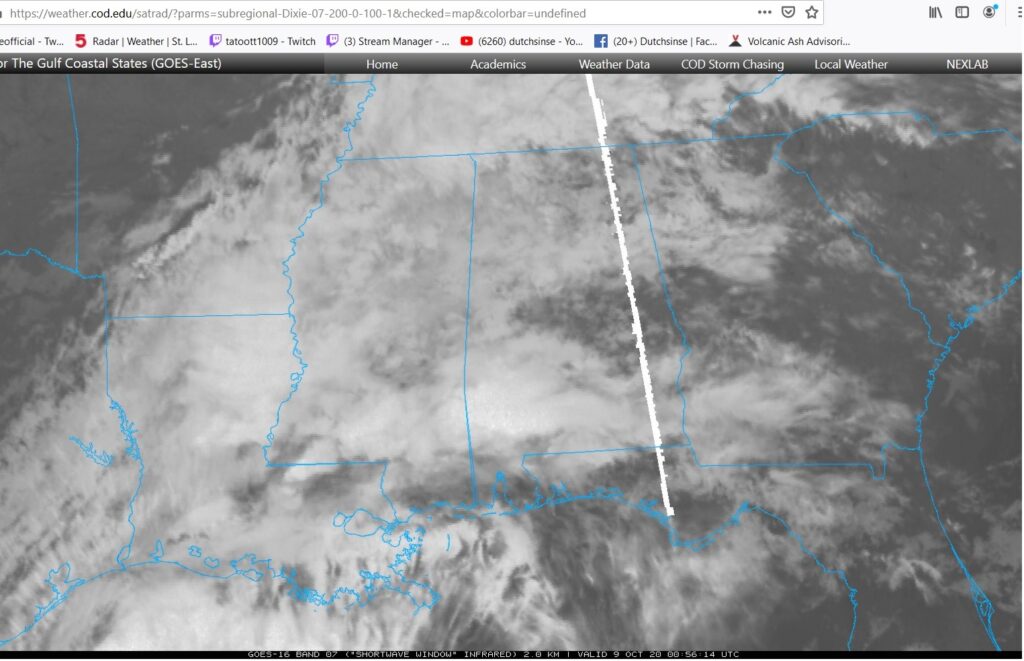
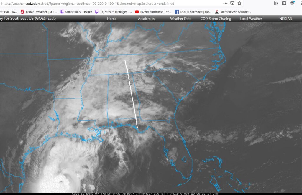
Link to see the beam live on Shortwave Infrared GOES 16 here: https://weather.cod.edu/satrad/?parms=regional-southeast-07-200-0-100-1&checked=map&colorbar=undefined#

If its us beaming out to ourselves.. creating a hot spot for some reason at ground level.. then we can move on and let them deal with moving to different frequencies to prevent civilians seeing it.

If its not us beaming down causing a hot spot on ourselves, then we’ve got problems.

I ask my viewers to please contact the Air Force Base (Tyndall AFB in Florida) ASAP!!! Send the Air Force this video with the links to see the beam in case they don’t already know this happened (and was observed by civilians such as myself).

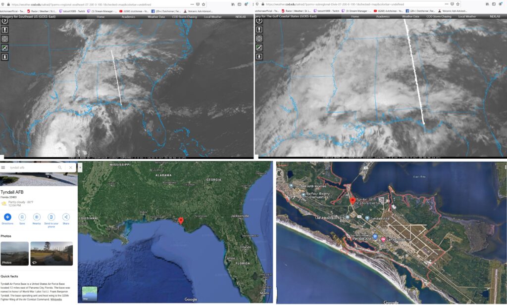
A beam of energy shooting down next to our Space Communications Wing base…. resulting in a physical hot spot being detected.

Links to see live on Shortwave Infrared GOES 16 here: https://weather.cod.edu/satrad/?parms=regional-southeast-07-200-0-100-1&checked=map&colorbar=undefined#

A second beam was captured beaming down to the SW Louisiana Lake Charles NEXRAD RADAR station.

It would appear both beams reside in the shortwave Infrared spectrum, and are targeting in on OUR United States RADAR systems along the coast of the Gulf. Targeting first at the NEXRAD along the coast of Louisiana, then a 2nd beam down at Tyndall AFB (the beam location showing an actual hot spot on thermal return via GOES 16).

This proves the DEW (directed energy weapon) beams previously captured were indeed actual events which were accidentally captured on weather satellite.

Posted on

4/14/2012 — Severe weather carries on = Be Alert TX, OK, KS, NE, SD, IA, MO, MN

watch the video alert here:

=============================

Currently.. MULTIPLE tornadoes breaking out in between Garden City , KS and Topeka, KS —- heading east / northeast towards Red Cloud , NE and Sioux Falls .

Look at the screenshots below.. if you live in these areas — time to prepare is now!

Use these links to monitor severe weather in your area : be alert and prepared in you’re in the Midwest, Northern Midwest, or South Midwest USA.

:

http://www.intellicast.com/Local/WxMapFull.aspx

http://radar.weather.gov/Conus/full_loop.php

http://weather.cod.edu/satrad/index.php

http://www.intelliweather.com/Broadcast.htm

http://weather.unisys.com/radar/rcm_radar.php

http://www.eldoradocountyweather.com

http://squall.sfsu.edu/crws/archive/satimgs_month_arch.html

http://nmq.ou.edu/

http://wdssii.nssl.noaa.gov/web/wdss2/products/radar/

http://www.srh.noaa.gov/srh/tropicalwx/satpix/

http://www.inmet.gov.br/html/observacoes.php

http://weather.rap.ucar.edu/radar/

http://www.srh.noaa.gov/oun/enhanced.php?map=2

http://cirrus.sprl.umich.edu/wxnet/radsat.php

http://vortex.plymouth.edu/nids.html

http://www.accuweather.com

http://weather.utah.edu/

http://www.atmos.washington.edu/weather/radar.shtml

http://www.stormsurfing.com/cgi/display_alt.cgi?a=glob_250

http://www.weather.com/maps/activity/aviation/

http://weather.engin.umich.edu/wxnet/servers.php

http://www.woweather.com/

http://www.goes.noaa.gov/GSSLOOPS/ecwv.html

http://livewxradar.com/

http://socc.caps.ou.edu/

http://www.weather.gov

http://radar.srh.noaa.gov/

http://www.inmet.gov.br/html/observacoes.php

http://www.met.hu/omsz.php

http://www.meteoradar.ch/de/

http://www.metoffice.gov.uk/weather/uk/radar/index.html

http://www.t-online.de/wetter/info/niederschlagsradar.html

http://www.ndbc.noaa.gov/

http://www.baynews9.com/weather/klystron9?animate=florida

http://www.tornadoalleylive.com/subindex/weather/maps

http://www.nrlmry.navy.mil/nexsat-bin/nexsat.cgi?BASIN=CONUS&SUB_BASIN=fo